DeLorme PN-40 GPS - First Impressions
- Details
 About the DeLorme PN-40 GPS
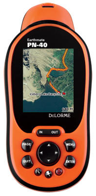
The PN-40 is DeLorme's premier GPS offering topographical mapping, street auto-routing, and tons of downloadable maps and imagery to get you the information you need. In addition to the world base map, DeLorme ships all GPS units with three discs that contain 1:100k hybrid road/topographical maps, making them the only company to ship maps of this detail with each unit. In addition to the topographical maps included, DeLorme offers aerial imagery, NOAA nautical charts, satellite imagery, and the super detailed 1:24k, 7.5 minute USGS quads all via the included Topo USA. The PN-40 is 'ruggedized' and certified to to withstand quite a beating. The PN-40 is certified to the IEC IPX7 standard for waterproofing and is sealed to protect the unit in high humidity and extreme cold environments. The PN-40 also sports an barometric altimeter and 3-axis compass eliminating the need to hold to the PN-40 flat to take compass readings. While neither of these items are absolute necessities, they do come in handy. (Lower model GPS units that don't include these features need to be moving in order to determine direction as they are based on position not orientation). The on-board compass eliminates the motion requirement and allows you to determine which way to face before you move -- it also allows you to shoot bearings for triangulation. It's important to note the DeLorme PN-40 and PN-30 are identical with the exception of the fact the PN-30 does not have the altimeter or the compass. The PN-40 has 500MB of internal storage (7.5GB on the SE model) but an SD card slot allows expansion up to 32GB which should be plenty of room for maps, imagery, tracks, and waypoints.
First Impressions of the DeLorme PN-40 GPS
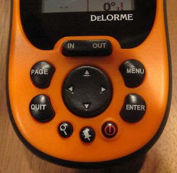
We were a bit disappointed that there was no Topo USA for Mac, only PC. Although transferring of maps is possible, it's not as straightforward as just having a Mac version available. We'll discuss the detailed method of transferring maps to your PN-40 using a Mac in the full review, but for now just know that it is possible. We've also found a way to add custom tracks to this GPS using your Mac (PC users will still use Topo USA). We'll have those details as well in the full review.  Out of the box, the PN-40 looks like a standard handheld GPS. Navigation of the device is done using the arrow and function buttons beneath the screen, and all the functions are pretty straightforward. The first time you start the device, it will take a few minutes to get a fix. This can be sped up by using the Menu->Set Current Location function. We were able to get a good initial fix in about 3 minutes on average. Once you have the initial fix, starting up the GPS 'warm' gets your location in usually 20 seconds or less. To get the PN-40 fired up, the batteries are installed by removing the cover, which is screwed on with two small D-rings. If you want to use the SD card, you'll need to remove the batteries to get to it. We'd prefer a micro-sd card slot that's accessible on the side (like some Garmin units), but it's not a big deal since you won't need to access the SD card very often. Once your maps are all installed (we loaded the Colorado maps to the SD card directly), you'll be ready to go. The maps include topo information, roads, and points of interest (POIs).While the PN-40 supports turn by turn navigation, it's not as robust as what you'll get from a dedicated in-car nav device, or even some other handheld devices. We really expect the strengths of the PN-40 to shine in the outdoors. This unit isn't really meant for road use (although it appears to work for that as well). The topo maps, the ability to load tracks (and convert them to routes), and the availability of additional map data means that this unit should be well suited for any adventure.
What We're Looking for in the DeLorme PN-40 GPS
We will be testing the PN-40 in many different situations including rock climbing, hiking, off-roading, and around the park. We'll be looking at quite a few things as we test the PN-40, from battery life and screen readability to GPS satellite sensitivity in cloud cover and resistance to the elements. Make sure you subscribe to our RSS Feed so you don’t miss the final review.

